Researched and compiled by Philippa Stanford including an extract from Glen Butler’s reminiscences included in TDHS’s book ‘Toowong Tramride from the Past’ by Leigh Chamberlain.

It seems that a significant proportion of the Chinese community in Brisbane were involved with market gardens. In 1916 there were 482 Chinese people registered in Brisbane. Nearly half gave their occupation as gardener with an additional 50 in associated businesses of fruiterer, fruit hawker or green grocer.

View looking over the Brisbane suburb of The Gap, with a Chinese market garden in the foreground, and Mt. Coot-tha in the distance, ca. 1950s. Image courtesy of State Library of Queensland.

In the period mid 1800s to the mid 1900s Chinese gardens could be found at Enoggera, Everton Park, Kelvin Grove, Toowong, and south of the river at West End, Eight Mile Plains, Runcorn, Belmont, Mt. Gravatt, The Gap, Sunnybank, Coopers Plains, And Yerongpilly. The ones at Enoggera, Kelvin Grove and Toowong were established first, before 1900, and the others later. It seems many of the gardens at Ashgrove were still operating in 1937 and the ones at Moorooka, Enoggera, Toowong and Newmarket in 1951.

At Toowong it seems there were Chinese market gardens close to Croydon St and Sylvan Road in 1913, Vera St (current basketball court of QASMT) and Bayliss St (near the current Scout Hall, formerly the Chinese Club)  Toowong. Further confirmation that there was a Chinese community in Toowong comes from historian Susanna De Vries, who writes that by ”the 1930s Toowong boasted an excellent Chinese Laundry in the Centre of the village.” There may also have been another market garden around the slopes of Stanley Terrace, Taringa.

The history of the market gardens in Vera St are interesting as it was  in the grounds of Karslake a house owned by Richard Langler Drew and then school teacher JB Fewings. Karslake was  a substantially-sized  property and reached from the corner of Miskin Street to where Sherwood Road bends to form Dean Street. It also ran down to the border of Toowong Creek. Later, after the deaths of Fewings and his wife, this back paddock was subdivided and sold. Various people purchased sections of land, and Fewings Street and  Vera Street were created. The land along the creek flats used as Chinese Market Gardeners, and was probably initially leased from Mr Fewings. Indications are that some time during the 1950s to 1960s, the land had been purchased by the Chinese market gardener at that time. When Toowong State High School opened in 1962 the Chinese market gardens were still operating, and the land did not become the property of the Education Department until later.

The market gardens at the back of ”Karslake”. Photographer not known but was probably Althea Munro Hull’s (nee Fewings) husband, Frederick Hull (aka Fred), who was a keen photographer. Photos sourced from the Fewings Family Album and provided by Fewings’ great granddaughter Genevieve Kennett].

In terms of the Bayliss St gardens Patrick Dixon recalled that his aunts who lived in Patrick Lane told him that after World War I the Chinese community grew Chinese vegetables on a fairly large scale. @The area was a creek eventually flowing into Dixon St., entering Brisbane river north of The Inn on the Park. Not sure of the exact timeframe but the land and building was sold for development when the Chinese club moved to The Valley.@

The gardens on Sylvan Street  were on private land facing the street which ran off Croydon Street, and adjoined the park. Several articles in local newspapers refer to Chinese Gardens on Cemetery Road (later Sylvan Road) Toowong.  In Toowong news the Queensland Times reported on 18 March 1890,  ”the water on the Cemetery Road rose considerably during Wednesday night and the Chinese gardeners were compelled to leave their humpies and camped on a high and dry patch in the middle of the road opposite the garden.” This article also comments on the Chinese Gardens on Sylvan Rd in 1913:
”It was decided that the Council should inspect the Toowong Creek Bridge with regard to the proposed alteration of the site, and further, that a visit should be paid to the land on Sylvan Road, known as the Chinese Gardens with the idea of considering its availability for recreation purposes”
pastedGraphic.png
Brisbane Courier (Qld. : 1864 – 1933), Wednesday 17 December 1913, page 6

Suburban growers took their produce to the main Brisbane produce market around Roma Street opened in the 1880s and also to a smaller one in South Brisbane. Several of these market shops were run by Chinese Fruiterers. Some of these were also shophouses and provided board and lodging for employees and out of town visitors. In 1908-1909 around one quarter of Brisbane’s Chinese population lived around Roma St. So possibly this is where the growers at Toowong would sell a lot of their produce although it is also possible that the local area purchased all the produce because most people went to the market gardens. In the High Street was Scholtz, the fruiter. They probably sourced produce from local market gardeners.

Reminiscences of the Chinese market garden at ToowongLeigh Chamberlain research and interviews

There was a Chinese market garden near the Butlers’ home in Vera Street, West Toowong. Glen Butler’s mother purchased the family property and house in about 1924-25, and Glen lived in this house all his life. Glen said he knew she paid £550 for it, which was equal to two years’ pay in those days.

Chinese people had first come to Australia in about 1839 to help with the pastoral industry. Later waves came during the gold rushes. Not all made their fortune and most could not return to China. Many chose to set up market gardens near towns and in suburbs.

Glen’s memories of the various Chinese gardeners are helpful. Bell’s shop rented rows of vegetables and came and picked them for sale in their shop. But by 1914 there was a Chinese market gardener in Carr’s Paddock. Leila Carr from Taringa (no relation to Carrs of Carr’s Paddock) recalls going with her parents as a child to buy vegies.

People went to the Chinese market gardens behind Toowong Memorial Park to buy fruit and vegetables. The produce was high in quality, but fertilized by human faeces.

Glen recalled (as told to Leigh Chamberlain):

”When I first remember the Chinese market gardener, he was ‘big time’. I can remember when we were kids, the shop around [in] the [other] street, Bell’s store, would buy a bed. A whole bed could be 50 yards long and full of lettuce. Ronnie Bell would come and pick them every morning, as he wanted them. Other shops in the area would buy a bed too…you would leave them in the garden, see — come around every morning and pick a couple of dozen.

The Chinese market gardener did not pick the produce. Ronnie’d pick them as he wanted them. He would pick as many as he would think he could sell, hopefully. To the best of my memory, the shopkeeper would come and cut them all as he wanted them, which was a good idea.

He’d say to Johnny, the gardener, ‘Right, I’ll give you this much money. In those days, it wasn’t really dear …he’d count them up and give him a couple of pounds for the whole bed, or ten pounds for the whole bed’, which worked out all right for the gardener. He had the bed sold before he even started.

Anyway, we — my brother and I — we got the idea that we could buy the lettuces for a penny and sell them for a three pence. We didn’t make much money out of it that I can recollect. It should have worked all right, but I think we tried to sell some to the woman over the road and she took them and didn’t pay us. We hung outside and they refused to pay us, so we took the lettuce back.

We had another lurk. There used to be horses in the paddock over the back. That paddock over there was Palmers’, as you know. [Now the grounds of the Academy of Science, Mathematics and Technology] That’s right, the son had horses. We used to go and collect the manure and sell it for three pence a bag. We busted our guts. We tried to make some money for Exhibition — sell it for three pence a bag — horse manure!

I don’t know the early market gardeners’ names. You’re only going back 70 years! I don’t remember what their names were. But he was quite good. I think that gradually, as time went, the others weren’t as good as the first bloke. But I can remember about three or four different market gardeners were there until the Tomai family arrived.

They (the Tomai family) would have arrived at the property in the early 70s, I suppose; and he didn’t really use the property as a garden. He was a cook. He started his own restaurant down Geebung way somewhere. I think he had a heart attack on the job and died.

The old house that Mrs Tomai had lived in had no water, no electricity in the house. I think it had an earth floor. What I remember of it, the walls were wood, but the roof, naturally, was corrugated iron. And that property, they owned it apparently. And when they sold it, it was bought by the government. As was the Palmer’s Paddock!”

Sadly Glen Butler has since died.

Note from author: Update on the story of the school:

After purchase by the Queensland Education Department the former Chinese market garden became the Toowong State High School’s netball courts and volleyball courts.

Locals were always allowed to access the pathway along the creek to Miskin Street, and it was a popular bikeway as well. Students accessed the school buildings this way as well. The school authorities seemed to be supportive of the locals using the lower oval, and often people were seen practicing their golf and walking their dogs. It was a great place to take little children to have a play, and kids would practice their footy skills with friends. The school’s tennis courts were available for hire as well.

Later, when the school was renamed as Toowong College, the former volleyball courts were leased to the newly formed Vera Street Gardens.

A suggestion in about 2003 that Toowong State School expand its campus to build facilities on the lower oval was canned. Instead the Toowong College was closed by the Education Department and the SMT Academy was established. Toowong lost its local secondary school, and the decision was taken without consultation to the local community.

Sources:

Joan Fisher, The Brisbane Overseas Chinese Community 1860s to 1970s: enigma or conformity, thesis, University of Queensland, 2005)

Queensland Times, Ipswich Herald and General Advertiser (Qld. : 1861 – 1908), Tuesday 18 March 1890, page 5, TOOWONG

Leigh Chamberlain; interview with Glenn Butler

TDHS Facebook discussions https://www.facebook.com/groups/202090111610987/permalink/442634654223197/?mibextid=zDhOQc

Further reading:

https://www.slq.qld.gov.au/blog/vegetables-directly-creek-table-chinese-market-gardens-brisbane?cid=

Photo of Lauriston from Page 28 of the Queenslander Pictorial, supplement to The Queenslander, 25 October, 1919. Image courtesy of  SLQ


Following a recent inquiry about a house in Chasely St, Auchenflower we found the interesting story of Lauriston House at number 27 Chaseley Street which had several strong connections to World War 1.

The house was originally owned by William Jack who was a draper with his business William Jack & Co being located in Queen Street.  He and his wife Mary and children lived in the grand house with beautiful gardens and a tennis court until October 1919 when it was sold. During their time in the house there were highs and lows for the family most notably including the wedding of their eldest daughter Mary Jack who was married at the house while sadly their son Corporal William Neilson Leslie Jack died of wounds in France in October 1917 at the age of 22. He received several medals for his service and his name is commemorated in the Toowong Memorial Park.

The house was sold in October 1919 to the Red Cross for the sum of £3000 who intended to use the house as a convalescent home for returned war nurses. The Red Cross had begun campaigning and fundraising for such a rest home in late 1918. It made this impassioned plea in The Telegraph, Thursday 31 October 1918:

How they braved the awful mud of Flan-ders and the terrifying shell fire at Trois, Arbres, and Grevillers. The dis-comforts and overwork of Poperinghe, the bitter cold and snow of Wimereux. All these trials were laughed at by those devoted women, who, in spite of them all, worked bravely and success-fully to save life and limb. How devoted they were, how devoted they still are. Already many, alas, have re-turned broken in health. What can we do for them? Homes and hospitals we have for our soldiers. Where is the home for our Queensland war nurses? I am ashamed to say we have none. Then give, give freely if you can, but give, and we will provide for our war worn heroines as a great and generous country, such as Queensland is, should provide.

Lauriston House was officially opened as a rest home for nurses on 18 November 1919 and could comfortably accommodate 13 nurses. It was described as having:

“six well furnished bedrooms, each containing two beds, a wide sleeping-out veranda, and a drawing-room, opening into a commodious dining-room, arranged with small tables. Gas is installed, and a large gas stove is a feature of the well equipped kitchen, and the septic tank system exists throughout the house. Other features include a well equipped laundry, store rooms, and linen cup-boards”. (Home for Nurses, The Week, Fri 21 Nov 1919, p5)

Accommodation at the home was open to nurses of the AIF, who despite being discharged as fit, needed some extra rest and attention. The nurses could stay for two weeks and must present a certificate from their ‘medical adviser’ in order to be issued with the ‘necessary card for admission. (Women’s Realm, Saturday 17 April 1920, page 15)

The home continued to operate until November 1920 when it “was reluctantly cleared, the very small number of nurses who required convalescent treatment not justifying the expense of its upkeep” (Daily Mail  Saturday 6 August 1921, page 8).

Following its decommissioning the Red Cross tried unsuccessfully to sell the house and it seems it was rented out instead finally being used in the 1930s by several musicians, Miss Merlena Uewells and Mr. Hardy Gerhardy, who advertised piano, cello and singing lessons and also hosted musical evenings.

The house remains high on the hill opposite the entrance to the Wesley Hospital although it has been modified extensively and it’s spacious grounds subdivided for other housing. The only tell tale connection to the original house is the chimney.


Research: Philippa Stanford, Nick Feros, Sharon Racine

Compiled by Philippa Stanford

Toowong District Historical Society - High street and Sherwood road Toowong Brisbane c1890

Compiled by Philippa Stanford for TDHS

A brief history of Toowong

In 1842, the former Moreton Bay Penal Settlement (est. 1825), was made available to free settlers with land in the CBD offered first. These early colonists did not recognise that the penal colony occupied key Meanjin land and waterholes which lead to numerous conflicts.

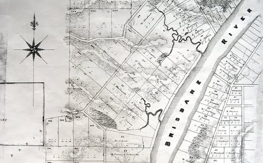
The 1850s saw the auction of land in what became the Toowong shire and the construction of several grand houses. On 8 July 1851 the first parcels of Crown Land along the river bank in the Milton area of the Parish of Enoggera were proclaimed as Freehold. Between 1 March 1852, when the first blocks were sold in Milton, and May 1854, all the allotments along the Milton and Toowong Reach of the Brisbane river that had been offered for sale had been purchased. Among those to first purchase land made in the district were James Charles Burnett, Ambrose Eldridge, Isaac and John Markwell, James Powers, Michael O’Neill, James Henderson, Henry Buckley, Robert Towns and George Christie (tenants-in-common) and Robert Cribb.

In Toowong, parcels of Crown Land were freeholded on 10 June 1853. Robert Cribb purchased the first block, an area of more than 38 acres, 3 rooms and 30 perches and described as Allotment 28, on 16 December 1853. There were also other sales of land further away from the river bank offered in the Toowong and Auchenflower area. Gradually settlement spread further westwards in the district. Much of the land was purchased by people who became well known figures in Queensland such as Robert Towns (after whom Townsville is named), Arnold Weinholt, and WC Bellbridge, the government printer.

By the 1860s Toowong is a recognisable place within the settlement of Brisbane. However there is a severe economic recession in Queensland affecting growth and development which is linked to the economic crash in England, May 1866.

The 1870s sees considerable change and growth in Toowong brought about primarily by the opening of the Brisbane Ipswich Railway line with a station opened at Toowong. The Toowong cemetery is established and a number of businesses and churches are developed along the commercial Centre of Toowong (Moggill Road between the station and Burns Road Bridge and also along Sherwood Road). Shops included a grocery, butchery, an ironmongery, a bakery, a drapery meant there was no need to travel further for necessities. There were also carpenters, contractors and stone masons. New housing estates of Sylvan Grove and Kensington are released for sale.

By the mid 1870s much of these large blocks were subdivided. Properties were purchased by people who became well known figures in Toowong such as architect, Richard Gailey and Professor Samuel Kaye, the musician and music teacher for whom Kaye’s Rocks is named.

In the 1880s the Shire of Toowong was created. Milton and Toowong are early village business centres with schools opening in 1889 and 1879 respectively, and each with railway stations (Milton station opened in 1884). The shopping precinct at Toowong features ribbon development, which is typical of rural pioneer times with the shopping strip strung along the main road, then called Moggill Road, but later renamed in 1885 as High Street.

The Brisbane economy is booming as is immigration and new commerce and this is reflected in Toowong which expands enormously as land estates are subdivided and put up for sale. Estates known as Villa Estates are established. These are sizable rural properties with farms and vegetable gardens, staffed with cooks, maids and grooms, large enough to feature a stable for a coach or horse and sulky to facilitate transport to the city where many were employed in government or banking roles.

The nature of residents in Toowong changes as many more working class families move into the area which had previously only housed wealthier families on large estates. This is assisted by the growth in public transport from Alfred Roberts Omnibus and the railway line.

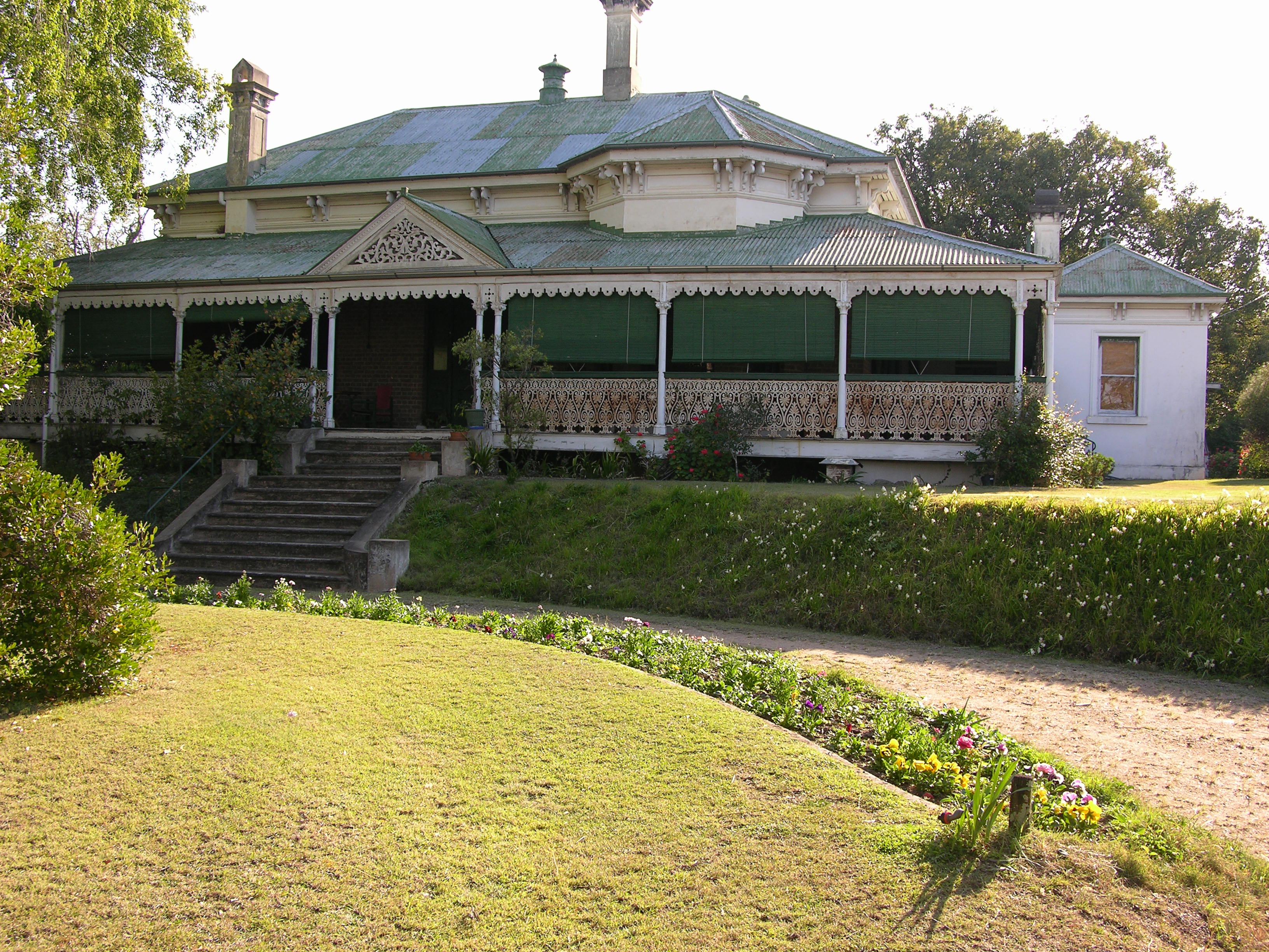
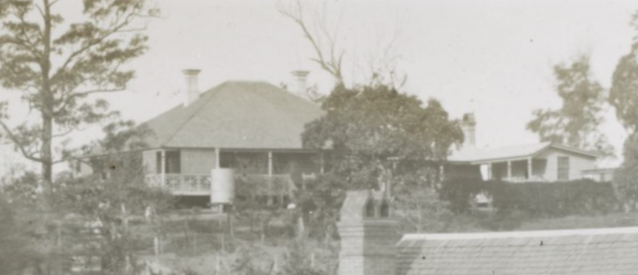
Following the economic boom of the 1880s Toowong is now a significant size and continues to develop with a number of fine houses were constructed in the shire including Dunmore, Fairseat, Moorlands. Davies states that, “Toowong was a satellite suburb favoured as a residential area by many politicians, civil servants, business leaders and professionals. As their large homes were set in spacious grounds, there were only 950 houses spread over four square miles. More than other suburbs, Toowong was a community in its own right with churches, private schools, sporting clubs and choral society.”

However the economic boom/excesses of the previous decade leads to a financial crisis with a decline in real estate and economic activity. Several banks suspend business and this combined with the floods in 1893 make it a difficult decade for Brisbane and consequently Toowong.

Queensland weathered this economic downturn better than its Southern counterparts and by 1895 there were signs of improvement, the colony was growing, unemployment had decreased, public works recommended and commerce revived. Davies p 142 The following decade saw a number of developments in Toowong including the electric tram, gas lighting and a pool established. In 1895 Pugh’s Almanac described the area as a ‘fashionable township’ with gas and water at the principal shops and villas.

From about 900 dwellings, the number grew to about 2500 by the early 1920s. In 1925 Toowong municipality was incorporated into the Greater Brisbane council.

References

ARCADIAN SIMPLICITY. J.B.Fewings memories of Toowong. Edited by Helen Gregory.
FEWINGS, John Bowden.Published by Bowen Hills. Boolarong Library., 1990
Auchenflower: the Suburb and the Name, John Pearn, Amphion Press, 1997
Brisbane Diseased: Contagions, Cures and Controversy, Brisbane History Group papers no. 25-2016, 2016
‘Historic Auchenflower’, The Brisbane Courier 21 Feb 1931, https://trove.nla.gov.au/newspaper/article/21671601?searchTerm=Historic%20Auchenflower
Historic Brisbane: Convict Settlement to River City, Susanna and Jake De Vries, 2013, Pandanus Press.
Lang Farm Estate Toowong: An 1877 subdivision and the people who made it home, Bull. L, 2019, Toowong and District Historical Society.
Milton, Queensland Places website, 2018, Centre for the Government of Queensland – University of Queensland, https://queenslandplaces.com.au/milton
Surveying Success: The Hume Family in Colonial Queensland, Davies, HJ, 2011, Brisbane History Gorup, Boolarong Press.
The 1893 Financial Crisis in the Colony of Queensland. Stanford, Jon. (2012). https://www.researchgate.net/publication/281280635_The_1893_Financial_Crisis_in_the_Colony_of_Queensland
Toowong, Queensland Places website, 2018, Centre for the Government of Queensland – University of Queensland, https://queenslandplaces.com.au/toowong
Warrior: a Legendary leader’s dramatic life and violent death on the colonial frontier. By Libby Connors, Allen and Unwin. ( https://www.brisbanetimes.com.au/national/queensland/queensland-historys-hidden-warrior-20150501-1my8ac.html);

Toowong Key dates

1839 – surveyor Robert Dixon and assistants Granville Stapleton and James Warner map land in the area (creating the Parish of Enoggera) for sale to new arrivals. He cleared land on Mt. Coot-tha of trees leaving only one as an anchor point. This gave the area its name of One Tree Hill. 1843 – one of the first major roads out of Brisbane is the one to Moggill with a stretch along the river later known as River Road and then Coronation Drive (1937)

1862 – Richard Langler Drew bought land on the outskirts of Brisbane and set up a signboard to describe the area: ‘This is the village of Toowong’

1864 – William Shaw apples for a licence for the Toowong Retreat Hotel which he formally purchased off Drew in April 1865. The Hotel is situated on Moggill Road consisting of six rooms as reported in the Brisbane Courier, 19 Sept 1864.

1865 – The Reverend M. Bell applies for land at “One Tree Hill” later known as Mount Coot-tha said to be an Aboriginal word for honey.

1871 – Toowong is chosen as the site for a new Brisbane General cemetery to replace the burial centre at Milton.

1872 – Alfred Roberts establishes a form of public transport, a horse omnibus between Eagle St in the city and TARINGA allowing people of more modest income to travel between these areas.

1875
The new Brisbane General Cemetery (also known as the Toowong cemetery) is officially opened.
First Indooroopilly Bridge is constructed.
the Brisbane to Indooroopilly (and Ipswich) railway line was opened, with a station at Toowong and Milton. The naming of the station at Toowong caused the whole district from Patrick Lane to the intersection of Moggill Road and Stanley Terrace to adopt the name.
The Regatta Hotel was opened on River Road (Coronation Drive) overlooking Toowong Reach.
Toowong Post Office established and operates out of Toowong Railway Station.
1877 – Toowong Town Council acquires the land to establish Anzac Park opposite the Toowong Cemetery. This land was originally gazetted as part of the Toowong Cemetary (Brisbane General Cemetary) in 1871.

1879
The Toowong Division was established on 11 Nov 1879 under the Divisional Boards Act 1879
Toowong State School opens in Aston St

1880
the more populated part of Toowong Division ( population 1000) was proclaimed the Shire of Toowong, while the remaining part of the Toowong Division was renamed as the Indooroopilly Division. The Shire of Toowong included Torwood and Milton (south of Boundary Road), Auchenflower and Toowong southwards to Toowong Creek. The western boundary approximated the summit of Mount Coot-tha.
Mt. Coot-tha area was gazetted as a public park/reserve

1881
Patterson’s Sawmill, the Bon Accord, moved to a site near Toowong Station which used to be a waterhole.
Hiron’s Biscuit Factory established in Sherwood Road

1883
One Tree Hill name is changed to Mt. Coot-tha (said to be an Aboriginal word for honey).

1886
The first Regatta hotel building is replaced by the present Regatta Hotel building which was designed by Richard Gailey .
The Royal Exchange Hotel in High Street, Toowong was initially known as the Railway Hotel, and it is also believed to have been built in the 1880s and designed by Richard Gailey.
Toowong Post office relocates to High Street. A purpose built facility was opened in High St in 1899.

1887 – The Metropolitan Rifle Range used by the Queensland Rifle Association was moved to Toowong (Anzac Park area) in 1887, then Enoggera in 1910 and finally Belmont in 1964.

1893 Floods in February and March devastate Toowong and see the railway line submerged and water rising 18 inches (45cm) over the second floor of the Regatta Hotel

1895 – Pugh’s Almanac describes Toowong as a ‘fashionable township on the Brisbane River’ where ‘gas and water are laid on in the principal shops and villas’

1903
The Toowong Shire became the Town of Toowong.
An electric tram service began in 1903 along Milton Road to the cemetery, and then along Dean Street and Woodstock Road to the terminus.

1908
Royal Exchange Hotel, established ca. 1908.
Gas lighting is established in Toowong., 15 Oct 1908 as reported in The Brisbane Courier.

1909 – Toowong Swimming Pool established on Coronation Drive by popular subscription on the western side of Coronation Drive.

1910 – new Toowong Rowing Club with boat sheds near the Regatta is formed. This replaced an earlier club based close to Park Rd Milton which was destroyed in the 1890 and 1893 floods

1911 – December – Toowong Pavilion opens – open air picture theatre around 51 Sherwood Rd

1913 – Picture Palace opens on Jephson Street (until 1916)

1915 – Anzac Park is established at Toowong opposite the Cemetery when the Toowong Shire Council purchases land previously set aside for the Cemetery

1918 – Toowong Memorial Park, Sylvan Road was officially opened in 1918 in honour of those who enlisted from the Town of Toowong during World War I

1920 – Stuartholme school opens in March with 5 pupils

1922
the Soldiers’ Memorial on top of the hill at the Toowong Memorial Park on Sylvan Road was dedicated
Savoy Theatres built the Gaiety in Jephson street which operated until 1961. It was renamed the Jubilee in 1935 (celebrating 25 years since the coronation of King George V)

1925 – the Town of Toowong was one of many local municipal authorities that amalgamated to form the Greater Brisbane Council.

1931 – Brisbane Boys College, formerly a day boarding college in Clayfield est 1901, opens at Toowong

1937 – River Road is renamed Coronation Drive

1957 – ABC Radio station moves to a new studio at Toowong

1961 – The Toowong Municipal Library Building was built 1961 on Coronation Drive opposite the Toowong pool, and was formerly the district library for the western suburbs.The library was designed by Brisbane City Chief Architect James Birrell, and is one of the few remaining examples of his work. The library is now used as commercial premises.

1962 – over the 1962-63 period the bus services replaced the Toowong tram service, the first move in a process to retire the metropolitan tram service in 1969.

1970s – Woolworths takes over the Brisbane Cash and Carry site (High street & Sherwood Rds)

1977 – Wesley Hospital built in the grounds behinds Moorlands house

1986 – Toowong Village drive-in shopping centre built (1986)

2013– ABC Radio moves from its Toowong site to South Bank Parklands

2016 – Woolworths Toowong closes

References

ARCADIAN SIMPLICITY. J.B.Fewings memories of Toowong. Edited by Helen Gregory.
FEWINGS, John Bowden.Published by Bowen Hills. Boolarong Library., 1990
‘Auchenflower: the Suburb and the Name’, John Pearn, 1997, Amphion Press, p21
“Classified Advertising” The Brisbane Courier (Qld. : 1864 – 1933) 19 September 1864: 1. Web. 16 Sep 2021 <http://nla.gov.au/nla.news-article1262147>.
‘Gentlemen of Honour – A history of Brisbane Boys College 1902’ – 2002 by Dr Noel Quirke.
Historic Brisbane: Convict Settlement to River City, Susanna and Jake De Vries, 2013, Pandanus Press.
“Historic Toowong ABC antenna tower demolished”, Jorge Branco February 2, 2015, Brisbane Times, Web 16 Sep 2021, https://www.brisbanetimes.com.au/national/queensland/historic-toowong-abc-antenna-tower-demolished-20150202-1340d1.html
‘Honouring our history’, BBC website, 16 Sep 2021, https://www.bbc.qld.edu.au/why-bbc/honouring-our-history/.
“LIGHTING OF TOOWONG.” The Brisbane Courier (Qld. : 1864 – 1933) 15 October 1908: 2. Web. 16 Sep 2021 <http://nla.gov.au/nla.news-article19544692>.
“Milton”, Queensland Places. Centre for the Government of Queensland, University of Queensland, web, 16 Sep 2021, https://queenslandplaces.com.au/milton
https://brisbanehistorywest.wordpress.com/2015/01/08/reflections-on-2014/.
The History of Mt. Coot-tha, Janet Spillman, 2013, Boolarong Press
Toowong: Bridging the Rail at Burns Road, Leigh Chamberlain
Toowong State School history, Toowong State School, web, 17 feb 2020, https://toowongss.eq.edu.au/our-school/history
“Toowong”, State Library of Queensland Blog, JOL Admin, 14 October 2008. https://www.slq.qld.gov.au/blog/toowong.
“Toowong”, Queensland Places. Centre for the Government of Queensland, University of Queensland, web, 16 Sep 2021, https://queenslandplaces.com.au/toowong
‘Village of Toowong – Drew’, https://trove.nla.gov.au/newspaper/article/1264341?searchTerm=Royal%20exchange%20hotel%20Toowong

Mt Coot-the picnic at waterfalls - image courtesy SLQ

Compiled by Philippa Stanford for TDHS

Mt. Coot-tha is part of the Taylor Range and lies Eight kilometres West of the Brisbane CBD. It was declared a public reserve in 1880 and by the 1930s it was a popular picnic spot.

Mt Coot-tha – Key Dates

1839 – surveyor James Warner and his team cleared the top of the mountain of all trees except one large eucalypt tree.

1865 – The Reverend M. Bell applies for land at “One Tree Hill” later known as Mount Coot-tha said to be an Aboriginal word for honey.

1873 – In 1873 the forests were declared a timber reserve to supply timber for railways.

1880 – Mt. Coot-tha area was gazetted as a public park/reserve

1882 – the Duke of Clarence and Prince George (later King George V) commemorated their visit to Mt Coot-tha by planting two Moreton Bay figs on the summit.

1883 – One Tree Hill name is changed to Mt. Coot-tha (said to be an Aboriginal word for honey).

1886 – first shelter shed is built around the location of the kiosk

1890 – Gold was prospected and mined at Mt Coot-tha intermittently from 1890-1950

1890 – Mt Coot-tha was proclaimed a reserve for native birds

1902 – around this time the metal plate engraved with directional lines pointing to distant landmarks and views establishes the site as a viewing spot.

1918 – Mt. Coot-tha reserve was put under the management of Toowong Town Council  and Brisbane City Council upon municipal amalgamation in 1925.

1918– larger kiosk is built and this forms the basis of the present day one.

1920 – The park is expanded under Mayor William Jolly.

1924 – Subdivision planned for Mt Coot-tha 1924 (SLQ image M E0986) did not go ahead as BCC Mayor Arch Watson wanted to prevent the erection of buildings on the mountain, The Brisbane Courier 2 Dec 1925 shows the council agreed to resume the land….

1930s – Mt. Coot-tha is a popular picnic spot with walking tracks

1942 – August 1942 -1945 Mt. Cootha area is used by the US Navy as an ordnance depot.

1960s – television towers are built

1970 – Mt. Coot-tha Botanic Gardens established

1976 – Mt. Coot-tha Botanic Gardens opens

1978 – planetarium at Mt. Coot-tha opens

1983 – new summit restaurant is built

References:

USN Mine and Torpedo Depot (Camp Cootha), 30 June 2014, Queensland WWII Historic Places, Queensland Government, Web, 17 Sep 2021,
https://www.ww2places.qld.gov.au/place?id=964
“Mt. Coot-tha”, Queensland Places. Centre for the Government of Queensland, University of Queensland, web, 17 Sep 2021, https://queenslandplaces.com.au/mount-coot-tha
Mt Coot-tha Reserve (Mt Coot-tha Forest)14 August 2001, Brisbane City Council, web, 17 Sep 2021, https://www.brisbane.qld.gov.au/things-to-see-and-do/council-venues-and-precincts/mt-coot-tha-precinct/mt-coot-tha-reserve
“Mount Coot-tha Lookout & Kiosk‘, Queensland Heritage Register, Queensland Government, web, 17 Sep 2001,
https://apps.des.qld.gov.au/heritage-register/detail/?id=601564
“Looking at Mt. Coot-tha”, by Janet Spillman, 7 October 2010, Queensland Historical Atlas, web, 17 Sep 2021, https://www.qhatlas.com.au/content/looking-mount-coot-tha
“SHIRE OF TOOWONG.” The Brisbane Courier (Qld. : 1864 – 1933) 14 September 1883: 3. Web. 17 Sep 2021 <http://nla.gov.au/nla.news-article3421971>.

Milton View across Milton Heights from Rosalie

Compiled by Philippa Stanford for TDHS

The suburb of Milton is thought to have been named after the house and farm owned by Ambrose Eldridge from the river to east of Cribb Street. He named his property  ‘Milton’ after his birthplace, Greater Milton, near Oxford in England.

Milton – Key Dates

1824 – John Oxley, Surveyor-General for NSW camps on the river near Milton as part of a visit to look at possible settlement sites

1843 –  the North Brisbane Burial ground was established at the current site of Suncorp Stadium

1853-4 – Milton House built by Ambrose Eldridge on high ground on the northern shore of the Milton Reach of the Brisbane River, east of Cribb Street.

1868 – the Bishopsbourne Anglican residence  was built at 233 Milton Road for Brisbane’s first Anglican Bishop, Edward Tufnell.

1870 – The first church (Anglican) is established near the burial grounds (now Suncorp stadium)

1874 – Tram service established along Milton Road

1875 – the Brisbane to Indooroopilly (and Ipswich) railway line was opened, with a station at Toowong and Milton.

1878 – The Milton Distillery, later Castlemaine Perkins (Fourex) brewery opened

1888-9 – Cook Terraces constructed on Coronation Drive by Brisbane Builder Joseph Blain Cook  as a two-storeyed brick row of six houses in 1888-1889.

1889 –  Milton State school opens in 1889 on the site of Red Jacket Swamp which was drained to allow construction of the school. It was originally called Rosalie State Schoo, but soon changed its name.

1890 – first State of Origin match held at Lang Park

1913 – The Morrow biscuit factory opened in December 1913 on the north-east corner of Coronation Drive and Boomerang Street. This became Arnott biscuit factory in 1949

1914 – Milton State School gets a pool making it only the second school in Queensland to have a pool

1915 – Queensland Lawn Tennis Association formed its headquarters at Frew Park.  across the road from Milton Park. The Milton Tennis Centre had 19 hard courts and four grass courts

1916  – old North Burial Ground Open is named Lang Park in 1916 and used for athletics, circuses and the accommodation of trenches during the war.

1930 – Milton Tramways Workshop established in Little Cribb Street

1956 – Frew Park hosted the Davis Cup

1964 – The Coronation Motel, The ‘Coro”, the in spot for functions and accommodation until it was demolished in 2002.

1988 – Savoir Faire precinct at Park Rd established with its iconic Eiffel Tower

1990s – Arnott’s Biscuit Factory moved to Geebung

1999– Milton Tennis Centre closes

2008 – Milton Bowl closes

2014 – Frew Park, including the Roy Emerson Tennis Centre, opens on  the former Milton Tennis Centre and Milton Bowl site.

References:

Bull, Lee. Lang Farm Estate Toowong: An 1877 subdivision and the people who made it home, 2019.
John, Pearn. Auchenflower: The suburb and the name, 1997.
John Pearn, ‘Auchenflower:  the Suburb and the Name’ Amphion Press, 1997, p21
“Classified Advertising” The Brisbane Courier (Qld. : 1864 – 1933) 19 September 1864: 1. Web. 16 Sep 2021 <http://nla.gov.au/nla.news-article1262147>.
“Milton”, Queensland Places. Centre for the Government of Queensland, University of Queensland, web, 16 Sep 2021,  https://queenslandplaces.com.au/milton
https://brisbanehistorywest.wordpress.com/2015/01/08/reflections-on-2014/.
“Milton – suburb of the City of Brisbane (entry 49246)”. Queensland Place Names. Queensland Government. Retrieved. 16 Sep 2021, https://www.resources.qld.gov.au/qld/environment/land/place-names/search#/search=Milton&types=0&place=Milton49246
Fisher, R & Shaw, B (Ed’s) People, Places and Progress. Brisbane History Group 1995
“Frew Park: former Milton Tennis Site”, Brisbane City Council, web, 16 Sep 2021, https://www.brisbane.qld.gov.au/things-to-see-and-do/council-venues-and-precincts/parks/parks-by-suburb/milton-parks/frew-park-former-milton-tennis-centre-site
“Milton Heritage Trail”, Must Do Brisbane, web, 16 Sep 2021, https://www.mustdobrisbane.com/outdoors-walks-heritage-trails/milton-heritage-trail-milton
“Rosalie, Brisbane’s Forgotten Daughter”, A.T. Miles, presentation 23 October 1980, web, 16 Sep 2021, https://espace.library.uq.edu.au

Auchenflower Toowong

Compiled by Lee Bull for TDHS

During the convict era the Brisbane settlement extended as far west as Boundary Creek, while the area beyond was home to the Jagera and Turrbul people.

However as more pastoralists and timber getters moved into the region the land was surveyed and the area was soon characterized by large farms with stately homes on hilltops. Chemist Ambrose Eldridge built Milton House in 1854 and the area west of Brisbane became loosely known as Milton. Further along River Road, Robert Cribb built Dunmore House and nearby was John Markwell’s 52 acre property Moorlands Villa, which was later purchased by the Mayne family. Other property owners included Randall MacDonnell, inspector of schools who built Rathdonnell House in the 1860s and Arnold Weinholt whose Weinholt estate was part of the family’s large holdings of grazing land.

By 1875 the railway line was constructed with stops at Milton, Toowong and Indooroopilly. As more people moved to the area, the large estates were broken up. The Markwells sold the western section of their property to John Ward, who built a grand colonial home on Milton Road. This property was bought by Thomas McIlwraith in 1880 and renamed Auchenflower. Meaning ‘field of flowers,’ the name reminded McIlwraith of his uncle’s Ayrshire estate in Scotland.

Sir Thomas McIlwraith was three times premier of Queensland and he refurbished and extended the house, which became the hub of Brisbane society in the latter part of the nineteenth century. With the premier living at Auchenflower, a whistlestop train station was added to service the local needs.

Immigration in the 1880s caused Brisbane’s population to expand rapidly. As the demand for land increased gradually more estates were subdivided into 16, 20 and 23 perch allotments and sold to working class families. In 1887, Torwood was broken into 161 blocks; in 1899 Robert Cribb’s Dunmore Estate was subdivided into 461 blocks; and in 1903 Auchenflower Estate was divided into 98 allotments. With a surge in building, a tram line was laid along Milton Road in 1904 to service this growing community.

Although these estates were divided into small allotments with a commuter suburb in mind, people frequently purchased several blocks, thus enabling them to build large federation style homes with room for stables and kitchen gardens, along with poultry, goats and the essential house cow. Hence the mix between small cottages and grand homes at the turn of the century, as the subdivisions continued.

A century later the pressure for land in the western suburbs continues at an unprecedented rate as the federation homes and cottages are rapidly giving way to units. Dunmore Terrace where Robert Cribb once lived is now dotted with high rise apartments and a section of Auchenflower House has been relocated to Tambourine, where it currently forms part of the Albert River Winery.

REFERENCES:

John Pearn, ‘Auchenflower:  the Suburb and the Name’ Amphion Press, 1997
Trove: The Brisbane Courier 21 Feb 1931 p19 ‘Historic Auchenflower’
“Historic Auchenflower: A Pleasing Landscape.” Article in the Brisbane courier, Sat 21 Feb 1931. https://trove.nla.gov.au/newspaper/article/21671601


Auchenflower – Key dates

1876 – Brisbane ironmonger, John Ward, acquires land near the present Auchenflower railway station and builds a substantial house.

1880  – John Ward’s house was sold to Thomas McIlwraith, Queensland Premier (1879-83) who named it Auchenflower after the McIlwraith family estate in Ayrshire, Scotland.

1887 – Auchenflower’s station opened in 1887

1892 – Moorlands House (now Heritage protected) was constructed for the Mayne family, designed by architect Richard Gailey and replaced an earlier timber structure that was known as Moorlands Villa

1903 – Auchenflower Estate subdivision offered for sale

1904  – the opening of the electric tram line along Milton Road

1904-5 – Drysllwyn (later Raymont Lodge) is built in Cadell St, Auchenflower, a homestead for Welshman William Davies esq. a gold mining magnate

1905 – Randall MacDonnell built Rathdonnell  house in Rathdonnell Street, Auchenflower.

1911 – Rathdonnell Estate, Auchenflower, (including Rathdonnell House) offers 84 allotments of land for sale on Milton Road, Wienholt Street, Irving Street (now Bangalla Street), Heussler Terrace (now Birdwood Terrace and Haig Road) and an unnamed road (Rathdonnell Street).

1913 – Auchenflower Presbyterian Church established in stables of Rathdonnell House in Weinholt st (1913). This later became the church Hall

1920 –  “Drysllwyn Estate” made up of 37 allotments was advertised to be auctioned

1922 – Auchenflower Infants’ Provisional School opened on 30 January 1922. It closed in 1960.

1923 – St Alban the Martyr Anglican Church, Milton Road was dedicated by Archbishop Gerald Sharp on 18 November 1923.

1927 – Auchenflower House was acquired for a Carmelite Monastery in 1927

1957 – The Chinese community, which once had market gardens in the suburb’s lower lying areas, established a Chinese Club in 1957, but it closed in 1982.

1986 – From 1975 to 1986, Auchenflower was officially a neighbourhood with the suburb of Toowong, but obtained independent suburb status on 16 November 1986.

References:

John Pearn, ‘Auchenflower:  the Suburb and the Name’ Amphion Press, 1997
Auchenflower, Queensland Place Names Search, Queensland government, web, 16 Sep 2021,
“Auchenflower – suburb in City of Brisbane (entry 49850)”. Queensland Place Names. Queensland Government. Retrieved 16 Sep 2021, https://www.resources.qld.gov.au/qld/environment/land/place-names/search#/search=Auchenflower&types=0&place=Auchenflower49850
“Item ID2627737, Queensland Place Names Act 1981 – Approval of Place Name. – Mr W.H Glasson”. Queensland State Archives. Retrieved 16 Sep 2021, https://www.archivessearch.qld.gov.au/items/ITM2627737
“St Alban’s Anglican Church Milton Road, Auchenflower”. Organ Historical Trust of Australia. January 2017, web, retrieved 16 Sep 2021, https://www.ohta.org.au/organs/organs/AuchenflowerAng.html
Auchenflower”. Queensland Places. Centre for the Government of Queensland, University of Queensland, web, 16 Sep 2021, https://queenslandplaces.com.au/auchenflower
“Advertising” The Telegraph (Brisbane, Qld. : 1872 – 1947) 6 May 1920: 12. Web. 16 Sep 2021 <http://nla.gov.au/nla.news-article179030156>.

Archer Street is named after Alexander Archer (1828-1890), manager of the Bank of New South Wales in Brisbane and a member of the Queensland pioneering Archer family. His wife was Mary Louisa, a daughter of Sir Robert Ramsay Mackenzie, 10th Baronet (1811-1873), a Queensland Premier (1867-68). The Archer residence, ‘Arley’, sat on the river bank at Toowong high above the flood zone of the Brisbane River.

The Archer brothers were explorers and pastoralists and were among the earliest European settlers in Queensland. Seven sons of William Archer, a Scottish timber mer- chant, they spent varying amounts of time in the colony of New South Wales, mainly in parts of what later became Queensland. A substantial number of locations in Queensland were either named by or for them. The first of the Archer brothers to settle in Australia was David, who arrived in Sydney in 1834. He was joined by William and Thomas in 1838. In 1841 David and Thomas, joined by their brother, John, travelled to the upper reaches of the Stanley River, an eastern tributary of the Brisbane River. There, near present-day Woodford, they established Durundur Station, a holding of 200 square miles (520 km2), which is equal to 128,000 acres (51,800 ha). Charles Archer arrived in Australia in 1841, and joined his brothers at Durundur in 1843.

Alexander Archer and his wife were aboard the R.M.S. Quetta, bound for England from Queensland, when on Friday, 28th February 1890, the ship foundered without any warning on a calm moonlight night within a few miles of Albany Island, at the entrance to the Torres Straits. Of the 293 people board, no fewer than 133 persons were drowned. The ship’s master was Captain Sanders, and with Captain Keatinge aboard, was piloting the ship through the Torres Strait. Destined for Thursday Island, the ship turned into the Adolphus Channel to round the Cape York Peninsula. The pilot was experienced, the weather fine and visibility good, but at 9:14pm the ship struck an uncharted rock in the middle of the channel near Albany Island. The rock ripped a hole through the plates from the bow to the engine room amidships, four to 12 feet wide, sinking Quetta in 5 minutes and sending 134 of her passengers to their deaths. When the disaster struck the Quetta had 292 people aboard: a crew of 121, comprising 15 European officers, 14 from other trades and 92 lascars from India; 70 Javanese in temporary deck houses, travelling to Batavia after working in the cane fields; and 101 other passengers. At the time, Quetta’s loss was thought to be the worst maritime disaster of Queensland.

The Quetta now lies on her port side in 18 metres (59ft) of water and is a protected historic shipwreck under A ustralia’s His- toric Shipwrecks Act 1976. As a memorial to the lives lost on the Quetta, the Quetta Memorial Precinct was established on Thursday Island, comprising a church (later a cathedral) a rectory and a Church Hall.

Bywong Street 1967 courtesy BCC

As the Toowong and District Historical Society has been meeting at the West Toowong Bowls Club since July last year (2020), it might be of interest to our members if some information is provided about the local area.

The West Toowong Bowls Club is located diagonally opposite the Queensland Academy of Science Mathematics and Technology (QSMAT) on the flats of Toowong Creek on the western side of Bywong Street. Change in the local neighbourhood has occurred over time, and some of these changes can be discerned after a close examination of the 1904 map.

In 1904, Bywong Street was then named Grosvenor Street. The name change most likely occurred ca.1938 onwards when the BCC insti- gated a policy of removing duplicate street names across Brisbane.

Grosvenor Street may have been named for Hugh Lupus Grosvenor, KG, PC, JP (13 October 1825 – 22 December 1899), the 1st Duke of Westminster. He was known as the Marquess of Westminster. His titles were Viscount Belgrave between 1831 and 1845; Earl Grosvenor between 1845 and 1869; and 3rd Marquess of Westminster between 1869 and 1874. He was created the first Duke of West- minster, the most recent dukedom conferred on someone not related to the British royal family, and created by Queen Victoria, in 1874. He was an English landowner, politician and racehorse owner. Although he was a Member of Parliament from the age of 22, and then a member of the House of Lords, his main interests were not in politics, but rather in his estates, in horse racing, and in country pursuits. He developed the stud at Eaton Hall and achieved success in racing his horses, winning the Derby on four occasions. Grosvenor also took an interest in a range of charities. At his death he was considered to be the richest man in Britain.

The origin of the street name of Bywong Street is not known at this stage, and more research is required. When the Brisbane City Council (BCC) decided to change street names it appealed to the public for suggestions. A list was drawn up, and as names were altered the next name on the list of suggestions was selected. Due to the manner of street name reselection there was no guarantee that the any new name applied had any connection to the area to which it was to be allocated. As names were used, they were crossed off the list. Sometimes there appears in the BCC files a notation which was added to the column against the new street name selected with infor- mation as to the origin of the name.
One suggestion that has been made is that a Chinese market gardener named Wong operated a market garden nearby in Market Street, and the street was named ‘Bywong’ because the street went ‘by Wong’. Was there a market garden at Market Street as well as on the creek flats at where the Toowong State High School was later located ? It is quite plausible that a local resident submitted this sug- gestion to the Brisbane City Council and it was adopted. If Irving Street, named for Mr William Irving, a long serving Town Clerk of Too- wong, could be renamed as Bangalla Street, after the home of the Phantom, anything is possible.

So perhaps there is a notation in the files of the BCC Archives that gives more information. This is yet to be researched.

Ray Steward came to Brisbane in 1967 and was appointed as Assistant Parks Manager BCC, and then as Parks Manager from 1970 to 1992. Ray had had previous experience working at the Royal Botanic Gardens Sydney, the Adelaide Botanic Gardens and the Albury City Council Parks Department.

After 25 years, he retired in 1992, and became a volunteer guide at Brisbane Botanic Gardens Mt Coot-tha.

The following memories of working at the Gardens were presented by Ray to the members of the Toowong and District Historical Society in 24 September 2010. He also shows photos of the gardens on a Powerpoint display.

Ray begins his talk by thanking Guest Speaker Programme Organiser Bruce Sinclair for inviting him to share his memories, and commenting that he had enjoyed the earlier discussion on aspects of Toowong’s history.

Thank you for having me here… and [it’s] great to hear all that history about the Toowong area. I’m only going to talk about the history that goes back to the beginning of the new botanic gardens at Mt Coot-tha.

I can’t do it without saying a little bit about myself and telling you a little bit about where I came from.

I came here in 1967 as the assistant manager to the Parks Department in the City Council. Of course, the Greater Brisbane City existed in those days and I knew nothing about all the councils that were amalgamated. I knew they had been amalgamated, but I knew nothing about it and the job I held was virtually in charge of the operation of the Parks Department; now I held that job for 3 years.

1970 came. The manager that was there left and I became the manager and I stayed the manager for a long time

…For the last 20 years I have been retired, but I have still been interested in the Botanic Gardens because I’m a volunteer guide at the gardens and make it my business to know what’s happening in the Brisbane Botanic Gardens at Mt Coot-tha.

Now let’s go back to 1970. In the [Brisbane City] Council, Clem Jones was the then Lord Mayor. The Botanic Gardens in the City was a functioning botanic gardens and the curator was Harold Caulfield.

Harold was one of my staff…and Harold and I talked about a new botanic gardens and never got real serious until the politicians of the day—in fact Clem Jones was the only one that did really show any interest. Politicians of the day decided to let out feelers that we’d have a new botanic gardens.

So we got busy and persuaded the operation to start a new botanic gardens and the first thing that happened—well, there had been moves to make a second botanic gardens in Brisbane at Long Pocket, but that happened many years before when Harry Oakman—do you know Harry Oakman? Have you heard about Harry Oakman? He was director of Parks and Gardens or the manager of parks and gardens for a long time after the war—he was interested in starting a new botanic gardens. But the system was never able to support it and it never happened—and that was to be at Long Pocket.

We actually tried…we put Long Pocket in the system again in the 70s and said, well this is a good site… here is another site. And the site that was chosen was the one at Mt Coot-tha.

‘Coot-tha’ means ‘Honey Bee’—and that’s a honey bee hive that’s being referred to. They are native bees and they don’t sting and they produce honey. The current curator Ross McKinnon has introduced a lot of hives into the gardens.

When the garden first started, it was opened in 1970. We know it was open then because that plaque was unveiled by Clem. I haven’t got a photo of that here today. Now on the rear of that plaque—has anyone ever seen the stone?

Audience: ‘No’

No, I know you haven’t—it’s still there, but it has actually been turned around and put back in and with shrub, with another shrub and trees close by, and you can hardly see it for trees and plants. And that’s what happens to signs in public places when somebody gets re-inventive and they put up another sign, and the other one goes.

But this one is still there. On the rear of this sign there is another plaque with all the names of the citizens of Brisbane that were on a committee that was formed that worked to support the start-up of the new botanic gardens and there were judges and aldermen and judges… I read the names last night so I could remember who they were, but I can’t remember the judge’s name….

There was a landscape architect who lived around this area somewhere by the name of Barbara van den Broek[i]. She went down to Sydney subsequently and worked down there. There was Harold Caulfield and there was me… and that committee met a few times, and we actually had a master plan done of the gardens.

Ray referred to a photo on his Powerpoint presentation, and said:

This is an early aerial photo of the gardens. The master plan was drawn by a man named Dean Miller. Dean Miller was the landscape architect in my department and he drew the master plan. And the actual plan, the design and functioning of the gardens as you see it today is still that master plan. And the master plan included the quarry over the back and it also included Anzac Park. Anzac Park became the first part of the garden that was developed.

I don’t have any photographs of Anzac Park. You will just have to look at this one for a minute while I tell you about Anzac Park. I know you want to know this story…I want to tell it anyway.

…we started work in Anzac Park; we put the roads in; we took out the house; we took out the scout den; and we built a big nursery. It was a very modern first class nursery of that day. Dean Miller, who designed that nursery had worked in England—he’d worked at Kew Gardens and at a lot of nurseries and he knew what he was doing. It was one of the best designed little nurseries of that time. It was the best, there is no doubt.

A member of the audience commented: ‘We had [the smell of] the straw and flies …we lived just down the hill.’ Ray replied, I’ll tell you about the flies later, just remind me, and then continued:

When the nursery was operating, it had a line of glass houses; it had an outdoor area; and a big potting shed—it was right where the dog park is now. It was a great little nursery. However, in the early days of developing Anzac Park as a garden, the plan included a tunnel under the Western Freeway… that’s not unusual for a garden to have a tunnel under a big freeway; it’s been done in other parts of the world and we were keen to do it and Main Roads were ready to do it.

Anyway, one Friday afternoon—this is the start of history, this is—one Friday afternoon Clem Jones said, ‘I want to meet you’. And I met him on the corner of Wool and Dean Street and we had a plan on the front of his car—and there was me and another officer. And he said, ‘why are you developing Anzac Park?’

I, well, I was, you know, an officer—er, does anyone know Clem Jones? I was just one of these junior officers—I don’t know what I said, but we immediately stopped work on developing ANZAC Park. That park never went back into the plan for development.

Subsequently it has been developed into another park—quite a good one. But we would have liked the nursery to stay as the nursery. It was taken down in the 80s when the economic rationalists, accountants in other words, got control of the council and it was costing too much. You could do it another way! You couldn’t do it other ways! I wasn’t the manager by that time; I’d been given another job.

[Showing photo of the sign]: Dean Miller designed the frontage and designed that sign—after Dean was here for 5 years, he went down to Wollongong council as director of parks there, and was involved in the Wollongong Botanic Gardens. If you go to Wollongong Botanic Gardens you will see the same sign. It’s got ‘Wollongong’, but it’s exactly the same: it’s a replica. That doesn’t exist anymore—it’s changed.

[Next group of photos:] That was the entrance in the early days. There’s the entrance now—much more classy, isn’t it? I think it is anyway. The palms were planted by the volunteer guides actually some 20 years ago.

A member of the audience asks: ‘Do you know if the council kept the old sign?’ Ray answers: No it was completely destroyed—that was one of the signs of the day. The standard wasn’t too good—that one was exceptional in those days.

A member of the audience asks: ‘When was the planetarium built?’ Ray answers: The planetarium was built from day one of the gardens—the planetarium went in—one of the early things that went there.

Referring to a photo on the Powerpoint display, Ray says:

That’s one of our rainforest walk signs, and you’ll notice young trees and mulch in behind. That’s part of the Australian rain forest which is just inside the gate on the right hand side.

The first curator of this garden was named Barry Dangerfielfd and he remained in the gardens for 5 years. Barry was a single man who lived in the gardens. He was a very dedicated horticulturalist and a very dedicated man for the botanic garden and he was quite a cultured gentleman. You’ll see him later on. I will show you a photograph of him.

Showing another photo, Ray explains:

That’s early construction and early planting of the gardens included the development of the pathways using granite crushed granite and concrete mix dry and spread and rolled and that’s how these paths were built. Those paths are still there and are the basis for the bitumen sealed paths that are still in the gardens.

[Showing another photo]: Another scene of the Australian rainforest area. The bamboos were just about endemic to that area, but they were planted by one of the families—we say they were planted by the Watkins Family, but whether they were or not, that could be fiction. We don’t know, but they are not native; they were put there. The story is they were put along the creek at shade for the local kids who went swimming in the creek, in that creek there.

Comment from the audience: ‘There are more down at Anzac Park.’ Ray replies: Yeah…it could be that they just spread down. A whole lot was done, but I can’t remember which mayor it was done under. I don’t know that story. I can’t remember it off hand.

Referring to the next set of photos, Ray continues:

Ok, now, that’s at the opening of the auditorium and the administration building on the 28th of June 1975. Five years have moved on from 1970, and in that photograph Clem Jones and the man with his finger pointing is Barry Dangerfield.

Ian Brusasco is the man with the European look and he was fairly supportive of what we were doing—he was our chairman later on. Without Clem Jones, that garden would never have existed because for the whole Lord Mayoralty he was supportive of the garden and what we did. And at his memorial service Ian Brusasco mentioned the fact that Clem had built this garden, and I think that this was a very significant thing. Clem was very much involved—not from the day-to-day action of what we did, but as a policy he supported the idea.

[Next photo]: The Administration Centre: now that’s changed a lot—now there is a herbarium up behind that—another big building.

The planetarium was under construction, finishing up on—I don’t recall the date of the opening of the planetarium, but it was fairly close to ‘75. It looks a lot different.

This entrance Information Centre was built from day one. For many years it had a council officer in that Centre and 20 years ago the volunteer guides started both at the City Botanic Gardens and at Mt Coot-tha. They started manning this particular building and they are there every day except Christmas Day and at Easter, I think—they are the only 2 days there’s nobody there.

Ross McKinnon came in the 80s, but before Ross Mckinnon, Barry Dangerfield. I’ll keep talking about each one of them as we go for a while.

Ross came in the Gardens in 82, and Ross is still there. He’s been Curator for a long time and what we see up there now is result of Ross’s work. [Showing photo]: That’s him there in the tie if you know him…

Audience: ‘Who’s the fellow in the pink shirt?’

Ray replies:

I don’t know! I think the guy with the shorts on is still working there—he’s the only other one I know. The others, I’m not familiar with them, but remember I was Ross’s boss in those days. We had a staff of 300 to 400 depending on what day it was.

The plan for the gardens was divided into zones of the gardens. And this is one of the first zones [showing another Powerpoint slide]: Australian rainforest area which I showed you earlier. [Showing another slide]: This Fragrant Gardens is one of the second areas that we planted—it’s all fragrant plants, and incidentally, a lot of the fragrant plants are all the same plants they used for herbs and medicinal purposes and has been the case for a 1000 years. I say 1000 because 500 years seems a bit short!

[Showing another slide]: This is the fragrant lawn and in behind here is a little water feature that was designed by Dean Miller and it no longer exists. Lovely, isn’t it? But it was just attached to the mains water. There was no pump or anything and water was just running away and it started to leak, so Ross got rid of it. I think it’s got plants in it now.

[Showing another slide]: The exotic rainforest: the big area of the first part of the garden was an exotic rain forest. See the sort of country that is. Now to develop that as a garden, what Barry did—because he supervised all this—Barry Dangerfield supervised the early part, put in the tracks following the contours, cleared some of the site of trees because in those days the usual way to plant rainforest was to plant them under something. Very soon after we started this, that method—we soon discovered—it was not necessary to plant rainforest species under the shade of other things. And nowadays it’s not done. The rainforest goes in, and off they go—but this is where your problem with flies arises.

One of the things we used to do—we used to gather organic matter, no matter where it came from, and a lot of it was sewage sludge. It was spread on the ground in all these places and not little thin layers. It was mulch and the mulch in all these areas was put in that thick. We cultivated it as best we could and then used thick mulch—and part of the mulch was the sewage sludge. And in time, with sewage sludge, were the flies.

And we would get inordinate complaints about the flies, and we would treat the area, and I think it did get rid of the flies. [To member of the audience: Did it get rid of flies in the 80s? Audience: ‘I can’t remember. I can remember before my kids were born, they were pretty bad. Someone said they ripped the straw from the stables full of cow and horse manure and urine and sometimes, you could smell it.]

Ray continues:

It wasn’t decomposed. It was just spread on the ground. You’ll just have to wait till it all breaks down’. Did we say that to you? He was an old hard case type who didn’t mince his words. Said you just have to wait till it all breaks down—we call it ‘tough love.’

One incident in particular—a real bad incident—I was going in my car up Mt Coot-tha and I had an accident in my car chasing these wretched flies.

Anyway, that’s what we used to do—that was our process for getting those gardens underway. It was Brisbane schist on that side of the hill. In fact, it’s all Brisbane schist—probably the poorest country in Brisbane to try and grow anything.

[Showing another slide with a photo from the Powerpoint presentation:] That’s taken in the same spot [as the previous photo]—so you can make a difference, can’t you?

Audience: ‘Crystal Creek…that’s what the locals call that creek. Crystal Creek’. Ray: I’ve never heard that name. Person in audience: ‘Some people have told me that. Ray: You could be right.

Ray shows the next few slides and provides a brief explanation about each:

Right, continuing up the hill from that last photograph, we get to the exotics, then through the exotic rainforest, and there’s a lookout. That was the original lookout designed by Dean Miller and built by Works Department engineers, and it no longer exists because there’s another lookout higher up the hill associated with the big lookout at the top of the hill.

[Next slide:] And it looks like that now—there’s no lookout; there’s trees all around.

[Next slide]: Another spot in the rainforest area. One of the things that Barry Dangerfield did was to build features in the creeks. These creeks were like that top one on the middle right going up the hill, and [next slide:] that’s what they look like naturally. They’ve been cleared a bit. All the creeks were augmented with rock features all the way up and the water reticulated back down.

Keep your eye on that white stone here [pointing to stone]—just keep your eye on that one. [Showing next slide:] That’s what it looks like now.

And you can see that more stone has been put in—the quarry being next door was a wonderful asset. If we’d had to pay to cart stone long distances, then it would have made it a very much more costly job.

[Next slide:] This is the site of the Dragon Bridge just below the exotic garden.

Now this area looks nothing like what you see there now. That was a wooden bridge that went in, and that palm (pointing out a palm tree)—you will see a dual palm in front of the truck that was moved by Barry Dangerfield very early in the life of the gardens from the university—they had it. It was a rare palm and it’s still there.

That’s below the Dragon Bridge.

[Re next slide:] That’s the Dragon Bridge completed, and that palm is on the left-hand side there.

On the right-hand side of that now is a huge fig tree—no, that’s not it! That’s what the creek augmentation stone looked like in the early days. There’s the Dragon Bridge now in 2005.

[Re next slide:] Now that’s Barry Dangerfield—Barry was very interested in singing and when he died several years ago, we suddenly discovered he’d written poetry, and some of his friends put his poetry together in a volume which I’ve got at home and I must get it out. He did write some poems while he lived at the gardens and they’re about the gardens. I must get them out. I should let people hear them.

That’s one of the features of the waterfall—of the rock treatment of the waterfall. It’s there still working like that. One of the features we were pleased with was the water system that was installed in this garden.

Many gardens have water systems installed that break down—and never go again. This one was put in by the Council water supplier and it was certainly over planned—but it still works today and that was Harold Caulfield did! And Harold was instrumental in that. [Re next slide:] After Barry left, Harry was instrumental in keeping the exotic rainforest going and developing—that’s him standing amongst it, and he did a lot of hard work and a lot of planting in that area.

[Quickly showing several more slides]: That’s another scene in the exotic rain forest and another one.

This is taken in the horticultural area—with what’s known as the—on this side it’s all been changed—on this side now, this is South African plants, and this has horticultural plants from all round the world.

Now the first lagoon came in ’75 and was built by engineers who were at a conference. More scenes of the lagoon…lagoon again…wonderful stepping stones… we are not allowed to use anymore because somebody might fall off them.

There’s Harold Caulfield and his team building the pathway around the lagoon. That pathway is still functioning and has not caused any problems, which is very good.

[Final slides]: The glasshouse which was built opened in ’77, and looking at it today from the same spot.

[i] Barbara Ruth van den Broek (22 August 1932 – 24 August 2001) was a New Zealand-born Australian architect and landscape architect.

Badger’s house Arlington, Toowong Brisbane

Badger’s house Arlington; now known as Endrim

Address: 28 Woodstock Road, Toowong

Arlington was built in 1905 for American Joseph Stillman Badger. Badger named the house Arlington in honour of the United States National Cemetery. He became known as ‘Boss Badger’.

Badger, a qualified electrical engineer, came to Brisbane in 1896 at the age of forty-five on behalf of the General Electric Company as its chief engineer to oversee the electrification of Brisbane’s out-dated horse-drawn tram network for the Brisbane Tramways Company (BTC).

After the sudden resignation of BTC project manager, Mr Walklate, due to ill health in 1897, the BTC directors approached Badger to become not only BTCs Chief Engineer but also as to assume the duties of General Manager as well. Badger consequently resigned from GE. A proud American , Badger named the house Arlington in honour of the United States National Cemetery.

Arlington house in Toowong, 1906

Arlington, 1906 | Photographed by Frederick Munro Hull and courtesy of Genevieve Kennett [Toowong and District Historical Society Inc.]


Well-known local Toowong resident Percival Hanlon, who used to work at the BTC workshop prior to assuming the lease of the Toowong cross-river ferry, always maintained that the house sat upon tram tracks which were used as bearers. Speculation and rumour circulated Toowong as to whether this story was correct, so when the property eventually came up for sale many locals attended to check this out for themselves. As Hanlon’s son, also named Percival (‘Percy’), later related, ‘I went under the house and there it was!’

Verification that Badger had used tram tracks as bearers for his house did not dispel speculation, but instead added to it. As a result, particularly more recently, locals wondered whether he was using his position at the BTC to cream off monies from the Tramway Company for his advantage. Badger acquired a reputation which could be described in common parlance as being slightly ‘smelly’ and eyebrows were slightly raised at the notion of Badger’s integrity. The speculation resulted in an article being written a couple of years ago in the local newspaper Westside News which described Badger as being ’notorious’, which was the first time such speculation actually was recorded in print as being a fact (and without any supporting primary documents or evidence). Formerly, it was suggested in verbal asides only.

However, reminiscences collected by TDHS in 2003-05 from several elderly former residents, aged between their late 90s to over the age of 100, do not include a suggestion that Badger had a tainted reputation. These included the childhood memories of99 year-old Len Hall in 2003-4 whose parents operated the local shop in Woodstock Road across the road from Badger. So the speculation seemingly appears to be more recent in origin, gaining more credence since the decade 2000-10 when the earlier generation of residents had by this time died.

To further investigate these innuendoes, TDHS examined the title deeds for the property. One person keen to know the truth was Percy Hanlon who did the legwork. The information was passed onto Badger biographer David Burke (then researching for his book titled One American Too many Boss Badger and the Brisbane Trams). David kindly provided the information that the names on the title deeds were board members of the BTC.

This implies that Arlington was financed by the Brisbane Tramways Company, possibly as part of an executive salary package, but Badger appears to have had a free hand in the house’s design as the architecture has an American flavour. It would seem that more than half a century later speculation fueled by ignorance has sullied Badger’s reputation. But at the time the house was built, the fact that the BTC owned the house was well-known, and hence no eyebrows were raised at the mention of Badger’s name at that time. Otherwise, why would the upper echelons of Society so admire Badger, socialize with him, queue up to pay patronage to him and do business with him? Badger’s business acumen was admired far afield, not only in Brisbane, but also in Sydney, Melbourne, and Adelaide and also as far afield as in London and New York.

Prior to living at Arlington, by 1900 Badger and his family (who had joined him from America) lived at ‘Belle Vue’, a large house and property on the hill in Miskin Street, just short distance from where the construction of the tramline along Milton Road to terminate at the Brisbane General Cemetery was in progress. This tramline opened on 22 July 1904. Then Badger moved his family to ‘Arlington’. This was when work commenced upon the extension of the tramline from the gates of Brisbane General Cemetery, down Dean Street, and into Woodstock Road to terminate at the (Toowong) Tram Terminus situated just near his front gate. The Toowong Council had campaigned to extend the tramway down to terminate at Toowong, and there were plans to build more termini along Sherwood Road. But to protect its suburban railway traffic, the Railways Department made sure the track was kept apart from Toowong station and so the extended tramline and termini did not eventuate.

Badger used a gate built into his side fence to walk down concrete stairs built into the steep slope of the ridge to access the tram stop near to his residence where his private tram collected him to go into work. Claims published recently (in 2018) by The Courier-Mail that the Woodstock Road terminus is built upon Badger’s property are incorrect, as the terminus has been built behind the footpath at the base of the hill upon the publicly –owned Miskin Street road reserve.

Endrim House undercroft showing steel tram tracks.

Steel tram track floor bearers in the undercroft of ‘Endrim’ (2016).

A recent photo of the residence now known as ‘Endrim’ (2016). Photographs courtesy of Christopher Sapsford {Toowong and District Historical Society Inc.]


Badger was partial to moving. Between 1913-15, he moved again to Hargreaves Road, West End, and later elsewhere. He liked to move to an area where the tramway was being constructed so he was immediately upon the spot to supervise. Badger was very much hands on!

Due to both his role in the electrification and extension of the Brisbane tramway network and his hardline opposition to unionism and the role he played in the lead up to the General Strike of January 1912, the residence has ever since been associated with his name. However, people refer to it as Endrim, the name the property was later called, and not as Arlington.

Endrim has attracted more controversy lately with plans to build a childcare centre being lodged with the Brisbane City Council (BCC). Concerns have been expressed over a wide range of issues, with one being an expected increase in traffic and the another being the impact upon the heritage of the house.

References:

Leigh Chamberlain and Lindy Salter, Toowong; A tram ride from the past, Toowong and District Historical Society Inc., 2018, p.124.
Leigh Chamberlain, Interview with Len Hall, ca. 2003
David Burke, One American too many. Boss Badger and the Brisbane Trams, Queensland Museum, 2012.
Certificates of Title and survey plans, Museum of Lands, Mapping and Surveying